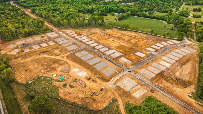
TL;DR: Cut and fill analysis measures how much dirt has to move on a site to reach design grade. For land developers, it’s the calculation that controls one of the largest variable costs in the budget. Drone mapping makes it fast enough to verify weekly instead of quarterly, which is where the cost savings actually live.
What Cut and Fill Analysis Actually Measures
Cut and fill analysis compares two surfaces: the existing ground and the design grade. The difference tells you the volume of material crews need to excavate (cut) or import (fill). Get that number wrong and you’re either paying for dirt that never moved or accepting a subgrade that doesn’t match the plan.
Traditional rod-and-level surveys spot-check the site. They miss large stretches of ground between checkpoints. Drone photogrammetry captures every square foot of the pad, so the comparison covers the entire surface instead of a sample. The volumetric analysis sits on top of that complete dataset, which is why the numbers tend to hold up better when a contractor disputes them.
Why Land Developers Care About the Number
Earthwork is one of the largest variable costs in a development budget. In one Propeller case study, drone-based cut and fill analysis flagged undercounted dirt on a residential development, saving the homebuilder client roughly $2,000 to $3,000 per lot, about $187,000 across the project. That’s consistent with what we see in the field. Big Falcon Digital clients regularly report savings of $2,000 to $4,000 per lot, and the $2,000 figure tends to land at the low end of what they actually capture. When you’re paying by the cubic yard, knowing the real number matters.
Two things go sideways without good cut and fill data:
- Overbilling. Contractors invoice for volumes that don’t match what was actually moved.
- Rework. A subgrade that’s a few inches off forces re-grading after crews lay aggregate, and the re-test cycle stalls the next trade.
We’ve seen the overbilling case firsthand. A general contractor in Tennessee used our drone mapping to catch a $450,000 discrepancy on excavation and hauling work. The full story is here.
That kind of catch only works if the data exists in time. A drone mapping flight collected before a draw request goes out gives the developer leverage. Collected after, it’s a forensic exercise.
How Drones Run Cut and Fill Analysis on a Live Site
Here’s a very oversimplified workflow:
- Set up a base station, collect GCP data, and fly the existing site with an RTK drone to capture a base topographical mapping dataset.
- Process the imagery into a high-resolution digital terrain model.
- Overlay the design surface from your civil engineer (CAD or DXF).
- Run the volumetric analysis to produce cut and fill quantities by region.
The actual deliverable varies. It can be a heat map, a contour comparison, regional volume tables, or some combination. The point is the same: grading crews see where to push and where to pull, instead of guessing. Good cut and fill analysis is only as useful as the terrain data underneath it, which is why accuracy and coverage matter.
With ground control points and RTK positioning, professional drone mapping can reach 1 to 3 cm horizontal and 2 to 5 cm vertical accuracy under ASPRS standards. That’s tight enough for grading sign-off on most subdivision pads.
How Often Should You Run a Cut and Fill Analysis?
Once is not enough. The value compounds when verification is part of the weekly rhythm. At a minimum, we highly recommend doing it during these milestones:
- Pre-construction: validates the original earthwork takeoff before crews mobilize.
- During mass grading: confirms what’s been moved before contractor invoices clear.
- At subgrade completion: as-built verification before crews lay aggregate.
- At final grade: documentation for handoff, stormwater compliance, and dispute resolution.
Running cut and fill analysis at each milestone turns a one-time number into a verification habit. A weekly flight on an active site costs less than catching one out-of-tolerance area after the paving crew lays asphalt. The math gets easier the bigger the site, and easier still on a fast-moving developer schedule.
The Bottom Line for Developers
Cut and fill analysis isn’t a nice-to-have on communities with more than 20+ lots, and especially on 50+ lots. It’s the verification layer that keeps your dirt costs honest, your schedule predictable, and your subgrade where the plan says it should be. The cost of running it is small. The cost of not running it shows up in the change order log often 45 to 60 days later, and sometimes creeps in as far out as six months.
The developers who get this right treat drone-based cut and fill analysis like they treat soil reports or geotechnical work: a standard, recurring line item, not an exception. The ones who don’t end up arguing about volumes they can no longer prove.
If you want to see what cut and fill verification could look like on one of your sites, we can send over examples of past work we’ve done for similar communities. Reach out anytime and we typically respond within one business day.