If you spend enough time around drone mapping vendors, you start hearing the same assumption: LiDAR from drones must be the premium solution, so it must be the most accurate solution.
That sounds logical. It just is not always true.
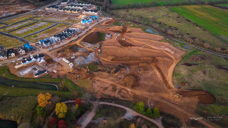
For land developers, the real question is not, “What is the most advanced sensor?” The better question is, “What is the right tool for the site conditions, deliverable requirements, and budget?” On most active construction sites, cleared development tracts, graded pads, and stockpile monitoring programs, photogrammetry is often the smarter answer.
That matters because many teams are not asking for ultra-specialized deliverables. They want clean progress documentation, dependable topographic mapping, and volume calculations they can trust for planning, billing, and reporting. In many of those cases, the required vertical tolerance is around half a foot. Our team regularly delivers much tighter results than that, often under 0.1 feet vertical accuracy, using a disciplined photogrammetry workflow we specifically built for construction documentation, which involves RTK, checkpoints, strong overlap, lower flight altitude, and camera settings tuned for mapping instead of just pretty imagery.
Why LiDAR from drones gets overprescribed
LiDAR is a strong technology. We offer it because it solves real problems.
But it gets oversold when buyers assume “laser” automatically means “better.” In reality, LiDAR from drones is most valuable when the site has conditions that photogrammetry cannot handle well, especially heavy vegetation. In an article from USGS, they note that Structure-from-Motion (SfM) photogrammetry does not reliably penetrate dense vegetation canopy the way LiDAR can, which is exactly why LiDAR remains essential for wooded corridors, overgrown tracts, and similar conditions.
Outside of that, the advantage often shrinks fast.
If you are mapping an active job site, a mass grading operation, a utility corridor under construction, or stockpiles in open conditions, the ground is usually visible. In those environments, photogrammetry can produce highly accurate surface models and volume calculations while staying far more cost-effective than LiDAR.
Accuracy is not just about the sensor
This is where a lot of buyers get misled.
Accuracy is not determined by whether the payload says “LiDAR” on the brochure. We also use LiDAR from drones, and that’s how we know that accuracy is the outcome of the entire capture system: positioning, control, flight planning, image quality, processing, and QA/QC.
Lower flight altitude improves ground sample distance and can improve detail and mapping accuracy. Proper overlap also matters. We recommend strong overlap because more overlap generally improves results, while poor overlap can reduce both relative and absolute accuracy. Our testing and experience has also show that checkpoints are required to independently validate accuracy, even when RTK or PPK is used.
We use RTK workflows, an Emlid Reach RS2, proper overlap settings, lower-altitude missions, and advanced camera settings designed for data capture rather than cinematic output. That is a very different workflow from sending up a drone on default settings and hoping the software fixes it later. When those field practices are dialed in, photogrammetry can absolutely compete with LiDAR for many development and construction use cases.
Where photogrammetry usually wins
For most land developers, value comes down to three things: speed, confidence, and cost.
Photogrammetry often wins because it gives you a reliable surface model, orthomosaic, progress visuals, and volumetric reporting without forcing you into a budget requiring LiDAR from drones on every site. Drone service providers are already a cost-effective way to capture detailed site data, and having them fly lower with the right imaging plan can improve deliverable quality even further.
That makes photogrammetry especially practical for:
- construction progress tracking
- topographic mapping on cleared or lightly obstructed sites
- stockpile volume measurements
- as-built site documentation
- recurring site visits where repeatability matters
In other words, if the site is visible, photogrammetry is usually the first tool worth considering, not the fallback.
Where LiDAR from drones still makes sense
This is not an anti-LiDAR argument.
It is a pro-fit-for-purpose argument.
When vegetation blocks the ground, LiDAR earns its place. If you need to model terrain through brush, tree canopy, or heavily vegetated areas, LiDAR is often the right choice because photogrammetry cannot consistently see through that cover. That is the use case where paying more for LiDAR from drones makes strategic sense.
The mistake is treating that specialty case like the default for every development site.
The real takeaway for developers
If you are a land developer, you do not need more technology. You need the right answer.
Sometimes that answer is LiDAR. But a lot of the time, it is photogrammetry executed with the right systems, the right field discipline, and the right validation process.
So before you pay for LiDAR on your next progress scan, topo update, or stockpile report, ask a better question: Do I actually need LiDAR from drones, or do I need a team that knows how to make photogrammetry perform?
That distinction can save real money across a development program without sacrificing the accuracy your project team needs.
If you’d like help with your site, we’d be happy to hear from you and see how we can help. Just click here.