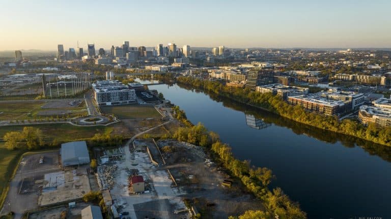
When it comes to construction, Nashville isn’t just growing—it’s accelerating past the national average, and it smarter needs tools like drone services to help.
Since 2020, the metro area has added approximately 136,000 residents, a 6.4% increase over four years (Source: The Kirkland Company). In comparison, the U.S. population grew by only 3% in that same period (Source: Census.gov).
Zoom in to the past year, and the difference is even sharper: the U.S. population grew by 1.0% in 2024, while Nashville posted a 1.37% increase, driven by job growth and in-migration (Source: Macrotrends).
This growth is transforming land into large-scale residential communities, commercial complexes, and mixed-use developments—fast. In 2024 alone, new residential permits being issued were trending towards 14,500 in Nashville’s surrounding counties (Source: Nashville Master Movers).
That’s more projects, more people, and more pressure on construction teams. And it’s exactly why drone services in Nashville are becoming not just helpful—but essential.
Why Nashville’s Growth Demands Drone Services and Solutions
1. Fast Growth Needs Faster Data
With thousands of units breaking ground annually, contractors, developers, and project managers often can’t wait days or weeks for survey results. Drone mapping and aerial imaging provide:
- Fast site maps
- Clear topographic mapping
- Accurate volumetric calculations for cut/fill, stockpiles, and material tracking
This allows teams to make informed decisions fast, keeping pace with the rapid build cycles required by Nashville’s market.
2. High Permit Volume Requires Precise Documentation
Nashville’s 2024 permit activity rivals the entire output of smaller metro areas. With that many active job sites, coordinating inspections, change orders, and stakeholder reporting becomes a logistical challenge.
Drone services create:
- Weekly progress photos from identical flight paths
- 3D models for fast site walkthroughs and progress reviews
- Orthomosaic maps for use in reports, permits, and owner updates
It’s an efficient way to maintain regulatory compliance and create a visual timeline that supports claims, inspections, and project transparency.
3. Urban Density Increases Risk and Delays
As Nashville infills and expands, job sites are getting tighter and more complex. Walking them manually increases both labor costs and risk exposure.
With drones, you can:
- Survey the site without setting foot on dangerous ground
- Cover large or multiple sites in a single flight
- Reduce the need for on-site inspections and field crews
This is especially valuable on multifamily and industrial projects, which often span dozens of acres or involve active equipment zones.
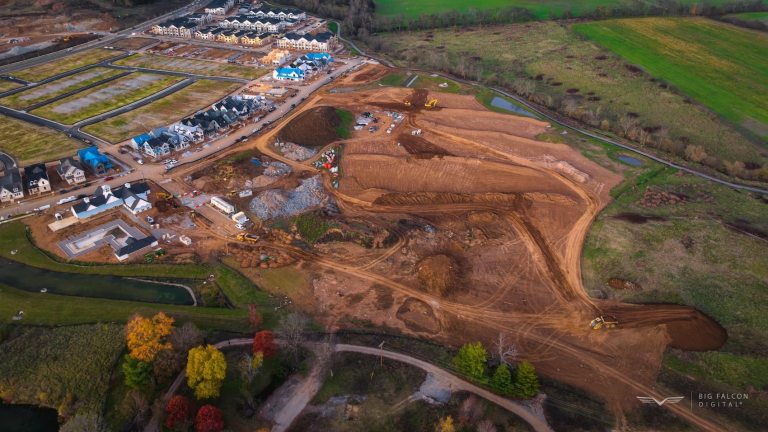
Real-World Use: How Drone Services Scale with Nashville
At Big Falcon Digital, we’ve tailored our services to meet the demands of high-growth cities like Nashville. Our construction drone workflows support every phase of the build lifecycle:
Pre-Construction
- Topographic maps and 3D terrain modeling to inform site layout and drainage planning
Active Construction
- Volumetric analysis to track earthwork progress and material movement
- High-res aerial updates to keep stakeholders aligned weekly
- Topographic verification to quickly ensure the site plans match the current site grade.
As-Built Documentation
- Marketing-ready aerials and final 3D models for client handover and compliance
Final Take: A Smart Solution for a Fast City
When a city grows this quickly, data and visibility become the competitive edge. That’s what drone services offer: faster decision-making, safer data capture, and scalable insights that support every phase of construction.
For developers and builders operating in Nashville’s high-speed environment, drone services don’t just provide efficiency—they unlock the ability to grow without chaos.
Ready to match the pace of Nashville’s growth with drone services?
Fill out our contact form, and we will be in touch within one business day.