Most people think drone survey data is only useful before construction starts — something for engineers to pore over in the design phase. But if you’re only using drone data before the first shovel hits the ground, you’re missing the real value. Because here’s the truth: drone survey data is just as valuable — maybe even more — once the job is underway.
Whether you’re managing a single site or overseeing multiple projects remotely, drone survey data gives you a clear, unbiased snapshot of what’s really happening. And in a world where timelines slip, subcontractors juggle priorities, and progress photos can be misleading, that kind of visibility isn’t optional. It’s essential.
The Myth: Drone Survey Data is for Precon Only
There’s a reason this myth sticks. Drones first made their mark in construction as a way to capture preconstruction data: topographic maps, 3D terrain models, etc. Great tools — but limited to the planning phase.
So when the dirt starts moving, many teams wrongly assume the drone’s job is done.
That’s the missed opportunity.
The Reality: Progress Is Visual — and Drone Data Makes It Clear
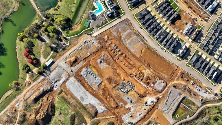
A well-run site moves fast. Crews are in and out, work happens in phases, and materials disappear from stockpiles quicker than you can refresh your spreadsheet. Progress reporting usually relies on walkdowns, quick photos, or what a foreman remembers from last week.
But none of that gives you an objective record.
Drone survey data does.
When flown at regular intervals — weekly, biweekly, or even monthly — drone surveys create a visual timeline of the site. Think of it like time-lapse photography, but with real-world measurements embedded in every pixel.
You’re not just seeing what has changed. You can measure how much.
- How much of that stockpile has been moved?
- How far along is the grading in that section?
- Did the subcontractor complete the pad like they said?
Drone data answers those questions without walking the site, chasing down updates, or guessing.
Not Just Images — Actual Intelligence
Let’s be clear: This isn’t just about nice aerial photos.
Drone survey data includes:
- Orthomosaic maps — High-resolution, top-down site images you can zoom into often with inch-level detail.
- Elevation and contour models — Useful for checking slopes, drainage, or foundation prep.
- Volumetric measurements — Essential for tracking earthwork and verifying subcontractor quantities.
What you get is a measurable, up-to-date, and unbiased record of progress — something you can use in meetings, RFIs, pay apps, or disputes.
And you don’t need to be a GIS analyst to understand it. A good drone partner with years of a trusted reputation (like Big Falcon Digital) translates the data into simple visuals and clear takeaways.
Better Communication. Stronger Accountability. Fewer Surprises.
Drone survey data isn’t just about knowing more — it’s about communicating better.
A project manager can open up the latest drone map during a coordination meeting and instantly align the team. No debate. No “he said, she said.” Just facts.
And for owners or stakeholders who aren’t on-site? Drone data becomes a communication bridge — a way to share real progress without the sugarcoating. That builds trust and reduces the pressure on your team to explain every detail.
What Drone Survey Data Can Look Like in Practice
Here’s how construction teams are already using drone survey data during active construction:
- Grading verification — Confirming cut/fill levels match specs before pouring foundations.
- Stockpile tracking — Measuring material quantities without manual counts or truck logs.
- As-built comparisons — Overlaying drone imagery with CAD files to catch layout deviations early.
- Schedule alignment — Visualizing whether work areas are progressing in sync with the project timeline.
In short: It’s not just nice to have. It’s a decision-making tool.
But wait. Isn’t a certified surveyor needed for all that? It depends. There are major milestones where a certified surveyor is required (boundary surveys, etc.) but there are lots of gaps where a trusted drone service provider, even if they don’t have a certified surveyor, can both capture and deliver the drone survey data needed. If you want to learn more about when to use a certified surveyor and when you don’t have to, check out this page from the Tennessee Board of Examiners for Land Surveyors.
The Bottom Line
Drone survey data isn’t a luxury or a “tech upgrade.” It’s a practical, repeatable way to see your project clearly from start to finish.
You don’t need to be an engineer to benefit from it. You just need to know what’s really happening on your jobsite and drone data delivers that faster and more accurately than almost anything else.
At Big Falcon Digital, we work with contractors, developers, and site managers to turn drone survey data into visual clarity — not complexity. If you’re ready to see your site from a smarter perspective, let’s talk.