You know the moment. It’s Tuesday at 7:14 a.m., you’re staring at a grading schedule, and your civil says, “We think the pad is within tolerance… but we’ll know after the next field shot.” Meanwhile the sales team wants a lot fit confirmation ASAP, and your owner’s rep just asked why the export pile looks bigger than last month. We’ve all been hearing more and more about drone mapping in Tennessee, and it’s because it’s paying off—not as “cool tech,” but as a practical way to tighten up decisions in the messy middle between plan set and dirt.
Land development managers tend to get outsized value from drone services because your job lives in the gaps:
- between engineered intent and field reality
- between weekly progress meetings and what actually got built
- between stakeholder confidence and “we’ll verify later”
A good drone partner helps you reduce those gaps with visuals and measurements your team can act on—without forcing you into a GIS rabbit hole.
Why land development managers get the most value from drone mapping in Tennessee
Land development managers are managing risk, velocity, and accountability across multiple lots, phases, and trade partners. Drone deliverables work so well for you because they translate field conditions into shareable, deadline-friendly artifacts: maps, exhibits, and quantities.
Just as important: drones are typically operated under FAA Part 107 rules for commercial work, which means you want a provider who is properly certificated and operating compliantly. Tennessee also points operators back to federal registration and compliance expectations—helpful when stakeholders ask “Are we allowed to fly here?”
Big Falcon Digital has an approach built around this “manager-first” reality—supporting planning, active construction, and as-builts with practical deliverables like topographic mapping/3D terrain models and volumetric analysis.
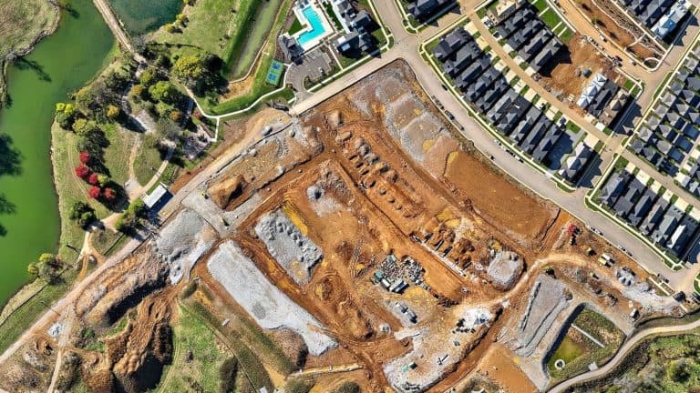
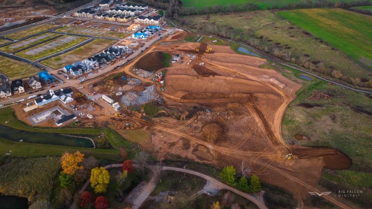
1) Topographic verification mapping: trust-but-verify for grading and pads
Topographic verification mapping is popular because it helps you answer the question that drives half of land development: “Are we where we think we are?”
Instead of relying on scattered photos or waiting for the next round of shots, you get a current surface you can use to:
- validate grading progress by phase (subgrade → post-grade → utilities and paving → final)
- spot drainage paths and low areas before they become punch-list drama
- keep cut/fill conversations grounded in reality, not gut feel
This doesn’t replace your surveyor—drone mapping in Tennessee is a fast, visual verification layer that keeps the team aligned and reduces “surprise grading.” Many mapping workflows reference industry accuracy standards (like ASPRS) when discussing how positional accuracy is defined and reported—useful context when your engineers ask, “How tight is this?”
Land-dev summary: fewer “I thought it was done” conversations, and fewer change orders that start with “field conditions differ.”
2) Lot fit exhibits: faster approvals and fewer redlines
Lot fit exhibits aren’t what people think about when discussing drone mapping in Tennessee, but this is where drone work becomes communication glue. A clean exhibit helps you prove (quickly) that a home plan fits a specific lot with the realities you’re dealing with: slope, tree lines, access, easements, utilities, and drainage intent.
For land development managers, lot fit exhibits are valuable because they:
- accelerate internal signoff (development → builder → civil → ownership)
- reduce redraws and RFIs caused by outdated base info
- help you defend decisions when someone asks, “Why did we shift that footprint?”
Land-dev summary: you move from “email thread ping-pong” to a single exhibit everyone can mark up.
3) Volumetric measurements of stockpiles: stop guessing and start managing
If you’ve ever had a weekly meeting hijacked by “How much base is left?” you already get why stockpile volumetrics matter when asking for drone mapping in Tennessee.
Drone-based volumetric measurements are popular because they give you a repeatable way to track:
- import/export dirt
- aggregate, base stone, millings, and spoil piles
- progress against the grading plan (and budget assumptions)
That means tighter forecasting and fewer uncomfortable surprises—especially when multiple subs touch the same material on different days.
Land-dev summary: better cost control, cleaner pay app conversations, and fewer disputes over quantities.
What to ask your drone provider before you schedule
Keep it simple and manager-friendly:
- How will you deliver the outputs? (PDF exhibit, surfaces, quantities—whatever your team actually uses)
- How do you coordinate with our surveyor/civil? (Most developers want alignment, not competing data. Big Falcon Digital notes that we’re not a licensed surveying firm, and we work closely with project teams—exactly the right posture for land dev.)
- How often can you fly? (Weekly? Milestone-based? “Before curb pour” is a common trigger.)
Make drone mapping a weekly advantage, not a one-time “nice to have”
If you’re managing land development schedules in Tennessee, the biggest win is consistency: repeatable flights that create repeatable decisions. When drone mapping in Tennessee is set up around topographic verification mapping, lot fit exhibits, and stockpile volumetrics, you get faster alignment, cleaner documentation, and fewer surprises.
If you want to see what this looks like on a real site workflow, explore Big Falcon Digital’s drone construction services and talk through a flight plan with us that fits your phases and reporting needs.