Let’s talk about a common dilemma I see on construction sites frequently when it comes to drone lidar services and photogrammetry.
A project manager calls and says:
“We’ve got tree cover, uneven terrain, and we need to get our volume estimates nailed down. Should we be using drone LiDAR services for this?”
It’s a fair question. But here’s the thing: it’s not completely about the tech—it’s about how you use it.
Most people think LiDAR is automatically more accurate. That’s not always true.
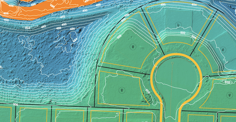
When photogrammetry is done right with RTK, GCPs, and a base station, you can get vertical accuracy within 0.1 feet. That’s construction-grade precision. And often, it’s more efficient and cost-effective.
So let’s break it down: LiDAR vs photogrammetry, without the hype.
What Are Drone LiDAR Services?
LiDAR (Light Detection and Ranging) uses laser pulses to measure distances from a drone to the ground, according to National Ocean Service. It’s great at capturing topography through dense vegetation or in complex environments.
Drone LiDAR services are ideal when:
- You need to scan through tree canopy
- You’re dealing with heavily wooded, uneven, or inaccessible terrain
- Subsurface utilities or hydrology demand a clean “bare earth” model
The point cloud it produces is dense, precise, and valuable. But it comes at a higher cost, with more data to process and manage.
What Is RTK Photogrammetry?
Photogrammetry creates 3D models by stitching together overlapping high-res images. Alone, it’s good—not great—for precision work.
But add RTK correction, GCPs, and a base station, and you’ve got a different beast. This is how we do it at Big Falcon Digital.
By combining:
- RTK-enabled drones
- Ground control points (GCPs)
- Base station corrections
- Strategic flight planning
…we regularly achieve vertical accuracy within 0.1 feet. That’s more than enough for:
- Cut/fill estimates
- Stockpile volumes
- Grading verification
- Topographic mapping
- In most construction environments, RTK photogrammetry delivers more than enough accuracy—with less overhead than LiDAR.
Drone LiDAR Services vs Photogrammetry (When Both Are Done Right)
Feature | Drone LiDAR Services | RTK Photogrammetry |
|---|---|---|
Penetrates Vegetation | ✅ Yes | ❌ No |
Accuracy (w/ controls) | ~0.05–0.1 ft | ~0.1 ft |
Ideal Use | Forested/complex terrain | Open sites, stockpiles, grading |
Processing Time | High | Moderate |
Cost | Higher | Lower |
So Which One Should You Use?
Here’s the simple answer:
If your site has tree cover or terrain you can’t easily access—go for drone LiDAR services.
If your site is mostly clear and you have an RTK setup with GCPs—photogrammetry by drone will often give you the accuracy you need, faster and often cheaper.
Final Thought: It’s Not a Showdown, It’s a Strategy
LiDAR isn’t better. Photogrammetry isn’t better.
The question is: what’s best for your site, your scope, and your budget?
At Big Falcon Digital, we run both. And we advise clients based on results—not tech buzz.
If your project needs precision, we’ll get it. Whether that’s a drone lidar services or drone photogrammetry.
Want Help Choosing the Right Survey Approach?
We’ll assess your site and recommend what works best based on:
- Terrain complexity
- Accuracy requirements
- Budget and timeline
- What’s underfoot and overhead
Contact us to learn more, and we will have an expert rep reach out ASAP.