Site is loading, please wait...

High-Accuracy Drone LiDAR Scanning for Complex Sites

Reduce grading risk, rework, and costly delays. Our drone LiDAR services capture true ground elevations beneath dense vegetation and complex terrain.
icons
Who We Serve

Defensible Topographic Data from Precon to Closeout

Drone LiDAR scanning for land development, construction, and industrial sites. Built for confident decisions and reduced delays.

Land Development

Reveal bare-earth elevations under vegetation for planning, design, and due diligence.

Construction

Verify grading, calculate cut/fill, and catch issues early

Industrial / Manufacturing

Support expansions and site work with topographic data for drainage, access, and earthworks.
While Big Falcon Digital is not a licensed surveying firm, we work closely with developers, contractors, and engineers to provide high-accuracy drone services that support site planning and verification.

What Our Clients Say

5.0 ON GOOGLE
da

Don A.

Principal, Southeast Venture

“Always responsive and reliable. They use industry-leading technology to add clarity to our development projects. Whether it’s high-res scans, topo mapping, or drone video, Big Falcon always delivers.”

Sarah W.

Land Development Manager

“I certainly see the value in the data. It’s definitely helpful to have. It’s very helpful to be ahead of the game when the developer says, ‘Hey, we’re done,’ and you can basically fact check them. And I think it’s money well spent even if what we find out is they’re doing everything perfectly to what we asked.”

Matt A.

Foreman, Kentuckiana Concrete

“Since we’re an out-of-town company, it’s nice to have some eyes in the sky when we’re not on a site. It ensures the site is ready for us to proceed with our work.”

LiDAR Use Cases

When Drone LiDAR Makes the Difference

Aerial LiDAR scanning for projects where vegetation, terrain complexity, or scale demand deeper ground visibility.
DTM of large community 1

BARE-EARTH TOPOGRAPHY

Generate high-density point clouds and DTMs that reveal true ground elevations beneath vegetation—ideal for planning and grading analysis.

GRADING & AS-BUILT VERIFICATION

Compare design surfaces to real-world conditions to identify deviations early and reduce rework.
Stockpile Volumetrics

CUT & FILL ANALYSIS

Compute surface-to-surface volume changes from LiDAR-derived terrain models to validate earthwork and support contractor reconciliation.
Drainage Flow Exhibit - Water Simulation 1

DRAINAGE & TERRAIN MODELING

Use accurate elevation data to evaluate watershed flow paths and stormwater planning across large sites.
Understanding the Technology

What is Drone LiDAR?

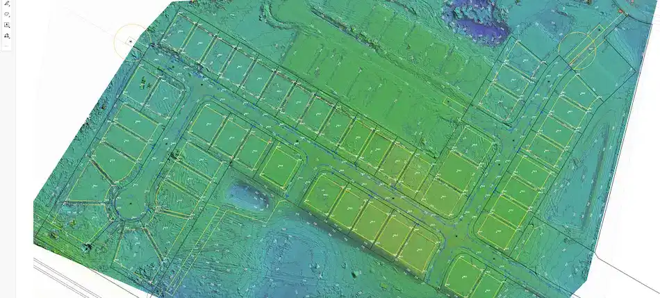
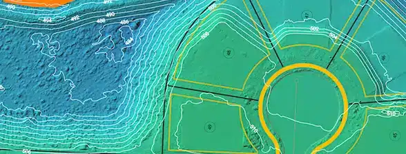
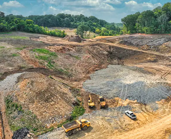
Drone LiDAR (Light Detection and Ranging) uses laser pulses to measure precise distances to the Earth’s surface.

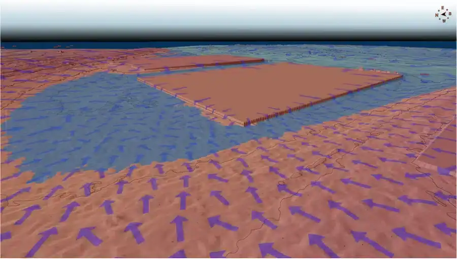
Aerial LiDAR scanning can penetrate dense vegetation and return multiple elevation readings from a single pulse. This allows us to model true ground surfaces beneath tree cover and uneven terrain.

LiDAR is not always required but when vegetation, scale, or terrain complexity demand deeper ground visibility, it becomes the right tool.

Key Advantage: Multi-Return Capability
Multi-return LiDAR allows a single laser pulse to capture both canopy and ground elevations—revealing bare-earth terrain even in thick vegetation.

We’ll help determine whether LiDAR, photogrammetry, or another scanning method is the best fit for your project, so you get the right solution without the guesswork.

Technology Visualization
Points Per Second
0 K
Why It Matters

The Business Case for LiDAR

When grading discrepancies, vegetation coverage, or terrain complexity create uncertainty, LiDAR provides defensible elevation data that can:
Land Development
Our LiDAR Workflow

OUR PROCESS

The disciplined system built for land development and construction projects.
step2

Step 1: Strategic Scoping

Define the location and area, vegetation conditions, required deliverables, and vertical accuracy targets before deployment.

step3

Step 2: Precise Acquisition

Deploy drone LiDAR to penetrate vegetation and capture precise ground truth.

Step 3: CAD-Ready Delivery

Receive clean LiDAR data ready for design, grading, and verification.

Frequently Asked Questions

What is the accuracy of your LiDAR data?

Our drone LiDAR systems typically achieve absolute vertical accuracy of 2-5 cm (RMSE), depending on ground control points (GCPs) and surface conditions.

What file formats do you deliver?

We provide industry-standard formats compatible with AutoCAD, Civil3D, ArcGIS, and more. Common deliverables include .LAS/.LAZ point clouds, GeoTIFF DEMs/DTMs, and DXF contour lines.

WHEN IS LIDAR NECESSARY INSTEAD OF PHOTOGRAMMETRY?

LiDAR is recommended when:

  • Dense vegetation obscures ground visibility
  • Terrain complexity impacts grading confidence
  • Large sites require efficient elevation capture

For open, unobstructed sites, RTK photogrammetry may provide sufficient accuracy.

HOW QUICKLY CAN LIDAR DATA BE DELIVERED?

Turnaround time depends on project size, but most sites can be scanned within 5 business days of a request and delivered within 7-10 business days after flight completion.
Drone LiDAR Services

Get Accurate Ground Elevation Data for Your Next Project

When vegetation, terrain, or scale create uncertainty, our drone LiDAR services provide the clarity your team needs. Let’s define scope, accuracy targets, and deliverables for your site.

Talk to a LiDAR Specialist

We’ll respond within one business day.
No obligation. We’ll help determine if LiDAR is the right fit for your site.

BIG FALCON DIGITAL®

Precision Drone Surveying Solutions